36 Days on Skis
Dec. 14 - Portland - 2 hours
Dec. 20 - Teacup - 3 hours
Dec. 21 - Portland - 7 hours
Dec. 22 - Portland - 4.5 hours
Dec. 23 - Portland - 2 hours
Dec. 24 - Portland - 1 hour
Dec. 27 - Solitude, UT - 2 hours
Dec. 28 - Solitude, UT - 3 hours
Dec. 29 - Soldier Hollow, UT - 3 hours
Dec. 30 - Solitude, UT - 4 hours
Jan. 1 - Park City, UT - 2 1/2 hours
Jan. 2 - Solitude, UT - 1 hour
Jan. 10 - Teacup - 3 hours
Jan. 16 - Whistler Olympic Park - 2 hours
Jan. 17 - Whistler Olympic Park - 1.5 hours
Jan. 18 - Whistler Olympic Park - 2 hours
Jan. 19 - Whistler Olympic Park - 2.5 hours
Jan. 29 - Williamstown, MA - 1 hour
Jan. 30 - Williamstown, MA - 1 hour
Jan. 31 - Craftsbury, VT - 4 hours
Feb. 1 - Williamstown, MA - 2 hours
Feb. 2 - Williamstown, MA - 1 hour
Feb. 15 - Diamond Lake - 3 hours
Feb. 16 - Mount Bachelor - 2 hours
Feb. 21 - Teacup - 4 hours
Feb. 28 - Teacup - 4 hours
Mar. 7 - Teacup - 4.5 hours
Mar. 13 - Meissner - 1 hour
Mar. 14 - Mount Bachelor - 2 hours
Mar. 15 - Snoqualmie Pass - 2 hours
Apr. 3 - Wanoga - 1.5 hours
Apr. 4 - Great Nordeen - 2.5 hours
Apr. 25 - Teacup - 2 hours
May 9 - Crater Lake - 4 hours
May 16 - Crater Lake - 3 hours
May 17 - Broken Top - 3 hours
May 22 - Crater Lake - 2.5 hours
Compare to last year:
2007-2008 Season Log - 42 Days on Skis
Sunday, December 14, 2008
Monday, July 21, 2008
2008 Ski Across Oregon Index
During February and March of 2008, I skied from Ashland to Sisters on the OSSA Trail Network.
Ski Across Oregon - The Concept
This post is a table of contents to all related Ski Across Oregon posts starting with the end and going backwards.
There were two attempts - version 1.0 and 2.0. Nomenclature is like 2.3 (i.e., day three of second attempt).
Epilogue - April 3 - BPA Powerline Corridor
2.6 - Friday, March 7 - THE FINISH!
2.5 - Thursday, March 6
2.4 - Wednesday, March 5
2.3 - Tuesday, March 4
2.2 - Monday, March 3
2.1 - Sunday, March 2
2.0 - Heading Back Out to Try Again
[Reload]
1.4 - Back in Portland
1.3 - Klamath Falls to Crater Lake
1.1 - Shut Down by Weather
Thursday, April 3, 2008
April 3 - BPA Powerline Corridor
After glimpsing this seemingly endless, straight corridor through the central Oregon trees, I had to come back and give it a shot. How far south does it go?
I skied approximately 40 miles south from Chemult along the powerline until it hit Route 97. It keeps going, but I was toast and stopped there.
For the most part, it's flat. The last few miles before hitting 97 are actually quite hilly and were tiring to get up and over in the heat of mid morning.
For the Trans Oregon, the powerline may be preferrable to the long (50 mile), remote snow mobile trail that goes from Annie Creek Sno Park in Fort Klamath up to Route 138. The powerline is close to the road and also crosses several roads. It is less committing than the "all or nothing" 50 miler.
The powerline is a crust cruising highway. An out and back from Chemult (Walt Haring Sno Park) to Route 138 at the Diamond Lake Junction is a perfect early morning 20 miler.
At several points along the route I could look straight down the cut for over 20 miles.
Here is what it looks like. And here.
Friday, March 7, 2008
2.6 - Friday, March 7 - THE FINISH!
Distance: 16 miles
Time: 3 hours
Conditions: Everything
A nice easy final day for the tour. Up from Bachelor heading north with immediate and constant great views of many Cascade peaks. Trail was alternately, packed dry, packed wet, frozen and windblown. The last downhill section into Three Creeks Sno Park was great. Several miles of continuous downhill, and the trail had just been groomed.
From Three Creeks I skied another five or six miles next to the road before the snow ended. Got a ride into Sisters and breakfast at the appropriately named Ski Inn. Probably the first time someone leaned their skis against the window. Two rides later into the outskirts of Bend, walked cross town to Century Drive, and got a ride to the car.
Done deal.
Thursday, March 6, 2008
2.5 - Thursday, March 6
Distance: 50 miles
Time: 7 hours
Conditions: Packed dry snow and some crust
I left Dutchman Flat Sno Park at Mount Bachelor at 5:00 AM for the trip down Cascade Lakes Highway. It went well. The last 15 miles where the road was plowed were more difficult, but still not too bad. All in all, another perfect ski trail. Not a soul encountered.
Averaged about 10 miles an hour for the first three hours. The first miles were a little out of control. It was dark, and I was just trying not to fall as the miles whizzed by. Steep downhill. Just watching in the lit radius of my headlamp for large, unexpected objects in the way. Didn't want to break a binding.
Hit Elk Lake Resort in an hour. Detoured in to see if the cafe was open, but no luck. No one about. With the large initial drop in elevation astern, it was now time to settle in to reality. Some miles to go. Skating was tough on the uneven surface. The road was packed but not quite smooth. Just when I would get into a rhythm a ski would fly off to one side throwing me off. I ended up double poling most of the way, which was plenty fast.
Going north on this road is the real scenic experience, and I was going south. However, I periodically looked behind me to survey the looming Cascade peaks. Mount Bachelor hung around for a long, long time. Beautiful sunrise.
Stopped to put on some sun block. Whoops - it's frozen solid. Luckily my pizza slices could not freeze - too many artificial, industrial ingredients. Tasty. Cold pizza remains a favorite on the trail.
With 15 miles to go the unwelcome sight of large snow banks appeared ahead. The road was plowed - kinda - but not open. Why they do this I do not know. No visible, obvious reason it was plowed. I could not ski on the road much anymore and had to go up on a bank. This worked ok for a lot of the remaining distance, but some times was just plain ugly. Double poling only now - too narrow to skate. Arms definitely feeling it, especially on the uphills.
Spotted Odell Butte from a ways and knew I was there. 50 miles and it's only noon. Changed into my running shoes (always prepare for the worst) and started walking east toward 97 and Gilchrest. I got a ride! This is a remote road traveled mostly by trucks, so this may have been the key ride of the day.
Out on 97 I got another ride. A skier with skis in the car! Holding out my skis while hitch hiking is my version of showing some leg. I know with the right person it will raise an eyebrow and maybe lead to a ride. Sure enough. I dangle these curious objects and see who will respond.
Great ride all the way to Bend. Hitching up Century Drive, which should have been the easiest in theory, was hard because it was afternoon and most traffic was coming down. A friendly guy dropped me part of the way up at Meissner. Only six miles from bachelor, but total no man's land. I started walking up the road, trying to look as downtrodden and hungry as possible. The sympathy ploy worked, and a nice guy who was coming down turned around and picked me up and delivered me back to the car. Bravo!
Good day. One to go! Weather is looking kinda blah, but hoping it hangs on just one more day...
Wednesday, March 5, 2008
2.4 - Wednesday, March 5
Rest day today as I prepare for the final few sections out of Bend.
Will ski from Bachelor all the way south along the Cascade Lakes Highway to Route 58, a distance of about 55 miles, and then hitch hike back to Bend.
Then the final section is from Bachelor north to Sisters.
Weather is perfect today (it was 5 degrees in Chemult this morning and clear) and should be good the next two days before a weekend disturbance.
2.3 - Tuesday, March 4
Distance: ~55 miles
Time: 6 hours
Conditions: Frozen crust and pavement hard trail
At last, the conditions I have been looking for. Weather has been clear the last few days, and the snow surface is now boiler plate. Today's skiing would be in two parts. First, I had to go back and get the section from Diamond Lake Junction to Chemult (10 miles), and then ski from Chemult to Crescent Lake on Route 58 (about 35 miles).
There is a superb powerline cut that runs parallel to 97 for miles near Chemult and south. If you have ever turned onto 138 from 97 heading for Crater Lake or Diamond Lake, you have seen it. It's right there near 97 and stretches off into seemign infinity in both directions. The corridor is almost completely flat. Perfect for skating.
I set off from Walt Haring Sno Park in Chemult, and when I hit the powerline cut I turned south and followed it all the way to where I had taken off the skis on the previous day at 138. This is probably the fastest I have ever gone for the longest sustained time on skate skis. Absolutely perfect speed conditions, and really got into a great rhythm. Got there and instead of hitching back I turned around and skied back. Figured it would be faster. Double the pleasure.
With the mile in and out from the Sno Park, total distance traveled was probably 22 miles, and it took around 2 1/2 hours. Super section, especially as the rosy fingers of dawn started to massage Thielsen and other Cascade fangs to the west. I highly, highly recommend this powerline. In fact I am tempted to go back and follow it as far south as it goes, which may be Chiloquin (near the Klamath Basin).
Got back to the car and headed into Chemult for some breakfast at the Big Mountain Cafe. Quick change back at the Dawson House and I headed back out for the ski to Crescent Lake. Conditions were perfect and stayed perfect all day because it never got that warm. The first 11 or 12 miles to near the Halfway House are a race course, with miles of gradual downhill where you can either tuck or pole. As the route turns west some hills start. Lots of hills. Was definitely starting to feel the long climbs later in the day, but the kamikaze downhills were a joy. I did not see a single person the entire way.
When I got to Crescent Lake, a wrong turn sent me west clockwise around the lake, adding about 5 miles, which I was not thrilled about. Worse, at this point the freeze disappeared and it was dry cold, new snow, often in shadows. My speed slowed dramatically. I made it to the Sno Park, which is located near an industrial style area near the railroad tracks. Got out to Route 58 and was picked up by Corvallis skier Bob who drove me all the way back to my car in Chemult, even though he was not headed that way. THANK YOU BOB!
I was back at the Dawson House and showered by 4:00 PM.
An epic day that truly showed what is posible when the conditions are right.
2.2 - Monday, March 3
Distance: 35 miles
Time: 4 hours
Conditions: Boilerplate crust and softened crust
Left Ashland at 3:30 AM to head back over to the Klamath Basin to pick up where I left off. This is an incredible valley if you have not seen it. It's just south of Crater lake and reminds me of Jackson Hole. Huge open flat valley bottom. In the right conditions, it could be a skater's paradise.
I decide to park at the northern end of this section at Annie Creek Sno Park and then ski back south to where I had ended up the previous day, and then back.
Finally conditions were perfect - rock hard trail and almost hard crust in the valley. When I broke out of the trees and headed out onto the huge open valley in pre dawn, it was an awesome moment. You could ski for miles and miles, which I did - then doubled back.
I did not have any plans for later in the day after this section, but I realized it was still plenty early and sufficiently cold to do more skiing. I drove around to the north entrance of Crater Lake to pick up the trail where I had left it last week.
This trail to Chemult is a rocket fast downhill for miles. I was able to pole and coast for a long way, even though it was now a little soft. I then left the trail and cut over to the road (Route 138) and followed that east all the way to 97. Skating along the road was great. Even though things were a little warmer in the afternoon, the surface was fully supportable. I cruised through the trees and ended at Diamond Lake Junction, where 138 hits 97.
Now I had the matter of retrieving my car, which was parked 15 miles up that laser straight section of road at the north entrance. I tried hitching. No luck. The weather along the crest was deteriorating. I fully intended to be warm and dry in the Dawson House in Chemult that night. So I began to run. I figured only 15 miles. I had my sandals, which worked pretty well. I actually felt fine and know I would have made it ok, but a Porsche SUV took pity on this lone runner about two miles into the slog, and I got a ride.
All in all, a great day in two amazing spots.
2.1 - Sunday, March 2
Distance: 22 miles
Time: 6 hours
Conditions: Packed and unpacked new snow
Set off heading north from Lake of the Woods on Route 140 (road from medford to Klamath Falls). Took only my skate skis, which turned out to be a mistake. Having only a small day pack was a big improvement on previous attempt to bring camping gear.
Started off with a big long downhill in dry, cold new snow. Very fast. Once it leveled off, problems began. Only a few snow mobiles had been by since the new snow, and the track was a little too narrow for skating. I slogged along as best I could, though uphills were definitely a problem.
At Pelican Butte, all tracks ended and I was now breaking trail. From there the trail descends steeply down into Rock Creek. Remember, I'm on skate skis. Definitely called for some creative skiing on the downhill. Eventually hit a logging road for a long slow exit to the Westside Road down in the Klamath Basin.
Started hitching and got picked up immediately by a guy in a 1963 Volvo sports car. I was back in Ashland that afternoon.
Thursday, February 28, 2008
Version 2.0 - Heading Back Out
My aborted first attempt this week could more accurately be titled "Hitchhike Across Oregon".
After bailing out day 1 because of snow, I had to hitchhike everywhere. My car was in Sisters at the planned end point of the trip, and my friend Sam had dropped me in Ashland at the beginning and then headed back to Portland. So when I arrived back in Ashland cold and wet the night of day 1 (via a heroic rescue pickup by friend Tim - thank god the cell phone worked!), I was without wheels. There is no better way to appreciate our complete dependence on the car in America than to be without one and try to do stuff. Just normal stuff.
In three additional days on the road with my pack and two sets of skis, I hitched seven rides, going from Ashland to Klamath Falls to Fort Klamath to Crater Lake to Chemult to Bend. On the final leg, after considering the benefits of an impromptu 30 mile run, I broke down and spent $45 for a cab ride from Bend to Sisters.
Anyway, the good news: hitchhiking does work and is a great way to meet people. The bad news: sometimes you have to walk for hours before someone stops. And some of the roads I am on do not see much traffic.
This time I am operating out of my car. I will leapfrog ahead on each section, hitching or running back to retrieve it afterwards. Shouldn't be too bad. This will also allow me to reconfigure gear as conditions require each day. I'll be much more mobile and self sufficient.
I am also going to change my approach. The pack had to go - it was weighing me down too much. I will now have just a small day pack, planning to hit the car or a motel each night. No camping. That eliminates a lot of hassle and weight.
One other possible change: skiing at night. The weather is warm right now. To get the maximum time on the freeze, I may need to ski at night. Being in the dark will introduce opportunities for getting lost on sections I do not know. On the sections I do know, darkness won't be a problem. Tradeoffs.
Yesterday morning on a perfect frozen surface I was able to cover as much distance in just over one hour as I did in seven hours on Sunday breaking trail through new snow. I need more speed.
Plan is to head back to Ashland Saturday, catch the evening show of "Welcome Home, Jenny Sutter" at the Oregon Shakespeare Festival, and start again on Sunday morning.
Stay tuned.
Wednesday, February 27, 2008
Day 4 - Back in Portland
Had two good days of skiing yesterday and today, but I need to change strategy to do this right.
A full spring thaw is in effect. Too soft to skate much beyond 10:00 AM. Skiing at night will be necessary to get the freeze.
Also, I have been hauling too much gear that I am not using. Need to take no gear on each leg - go like it's a day ski and then hit the car each day to resupply.
This morning I skied from Chemult to Route 58 on perfect, rock hard trail. At last! It was so fast. I was singing to myself the whole way. Too fast to skate a lot of the way. Just double poling and trying not to fall. Those are the conditions I need to get each section in.
Yesterday had a great ski from the South Entrance of Crater Lake around the west side then out the North Entrance on packed snow mobile tracks, a total distance of about 16 miles. I have dreamed of skiing out the North Entrance on a nice packed trail for some time. It was great. You can point them and pole for about 5 miles! When it flattened out in the Pumice Desert I was able to skate the rest of the way, even though it was soft.
More soon.
Tuesday, February 26, 2008
Day 3 - Klamath Falls to Crater Lake
Spent Monday (Day 2) hitch hiking to Klamath Falls. I was going to continue north to Bend but could not get a ride and stayed the night here. Incredibly, there is no bus north from Klamath Falls.
Last night I got the idea to head up to Crater Lake and put the skis back on. Not the original planned route, but still pretty good. I could ski from the south entrance around the west side of the lake, then out the north entrance to 138. At that point if conditions are not working, I can head over to 97 and hitch hike north. If things are looking good, I can resume the route and head north to Diamond Lake, then Route 58, Cascade Lakes Highway, etc.
I think this is a good plan. Main challenge is getting a ride to Crater Lake. If I can get north to where Route 62 breaks off 97, I shoold be in a good spot. Might have to do some walking this morning.
Monday, February 25, 2008
Day 1 - Shut Down by Weather
Attempt number one was aborted last night.
I left the Hyatt Lake Reservoir on Route 66 east of Ashland at 11:30 AM. There were snow machine tracks to follow for the first hour or two. After that, cutting through several inches of new snow got increasingly tough on the skinny classic racing skis. Apparently these trails are not traveled as much as I anticipated by snow mobilers. I thought for sure there would be lots of people out on a Sunday.
It stared to snow harder around 2:00 PM and eventually my ski tips disappeared below the surface of world class Cascade crud. Snow was sticking to tops and bottoms of my skis, reducing my movement to glorified snow-shoeing. I hit the Pederson trailhead on Dead Indian Memorial Highway at 6:30 PM and phoned a friend in Ashland for a rescue mission. 30 minutes later I was back in the Ashland Motel drying out gear. I had gone only about 25 miles.
Not sure what I am going to do now. With the new snow it will take another window of sun to regain the melt freeze cycle, which is needed for this trip concept. I may take a bus back to Portland, or hitch hike to the east side and see what it's like over there.
I have heard about several cabins on the trail where you can stay. Using these would help minimize gear carried. Right now I may have too much gear to go fast enough.
Friday, February 8, 2008
Ski Across Oregon
The Concept
A multi day continuous cross country ski trip (almost) across Oregon from south to north, on the east side of the Cascade Crest.
Background
In the fall of 2007 I discovered you can ski the entire length of Vermont (300 miles) on the Catamount Trail. I immediately wondered...why don't we have that in Oregon?
New England has the ski culture, but Oregon has the snow and elevation.
With its deep snow pack, high elevation, mild climate, existing network of forest service roads, and beautiful scenery, Oregon is an ideal place for a long distance cross country ski traverse.
Many roads and trails are groomed for snow machining in the winter. Packed surfaces allow for much faster ski travel than traditional backcountry conditions, which often involve breaking trail. What could take weeks in deep snow might take only a few days on packed trails.
The Route
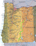
You can ski from Ashland (route 66 east of town) all the way to Santiam Pass on groomed snow machine trails, passing such amazing features as Crater Lake, Mount Thielsen, Diamond Lake, and the Three Sisters along the way.
There is a great map of the existing snow machine trails here.
If you are familiar with the PCT, the route goes a little to the east of that most of the way.
Estimated distance from Ashland to Santiam Pass is 250-300 miles. This is maybe 2/3 of the distance across Oregon from south to north. The remaining section from Santiam Pass to Mt. Hood is more mountainous, and east side access is restricted because of the Warm Springs Reservation. Present goal is just to ski the continuous snow machine trails from Ashland to Sisters or Santiam Pass.
Detailed Route Description
Moving south to north, from Ashland to Sisters, the route is naturally split into sections by road crossings.
Distances are estimates.
*Section 1 - Route 66 to Route 140*
Distance: 40 miles
Section 1 begins east of Ashland on route 66. There is a Sno Park near the entrance road to Hyatt Lake. The route ends at the Lake of the Woods Sno Park on Route 140, the road from Medford to Klamath Falls.
*Section 2 - Route 140 to Route 62*
Distance: 40 miles
Section 2 begins at the Lake of the Woods Sno Park on Route 140. Ski north past Pelican Butte and Cold Springs and finish at the Annie Creek Sno Park just outside the town of Fort Klamath. Amazing views down into Upper Klamath Basin.
*Section 3 - Route 62 to Route 138 / Chemult*
Distance: 70 miles
First big day. Section 3 begins at the Annie Springs Sno Park on Route 62 just north of Fort Klamath. Ski up the east side of Crater Lake National Park until you hit Route 138. Head east to the town of Chemult on Route 97.
*Section 4 - Route 138 / Chemult to Elk Lake Resort*
Distance: 60 miles
Second big day. Head north out of Chemult, cross Route 58, continue north on Cascade Lakes Highway to Elk Lake Resort.
*Section 5 - Elk Lake Resort to Sisters*
Distance: 40 miles
Continue north along Cascade Lakes Highway toward Mount Bachelor, head off to the north at Todd Lake and continue on to Three Creeks Sno Park in Sisters.
*Section 6 - Extra Credit - Sisters to Santiam Pass*
Distance: 25 miles
Not sure if I will stop at Sisters or continue to Santiam Pass.
In the Old Days
Long distance ski tours and races used to be more common in Oregon. The most famous example of this genre was the Crater Lake Wilderness Ski Race, which ran annually from 1927 to 1938. The 42 mile race climbed 2800' from Fort Klamath to Crater Lake Lodge and attracted hundreds of spectators.
In 1929 the race was won by Oregon ski pioneer Emil Nordeen, after whom the current Great Nordeen race at Mount Bachelor is named.
For an amazing read on the history of the Crater Lake Wilderness Ski Race, go here.
A multi day continuous cross country ski trip (almost) across Oregon from south to north, on the east side of the Cascade Crest.
Background
In the fall of 2007 I discovered you can ski the entire length of Vermont (300 miles) on the Catamount Trail. I immediately wondered...why don't we have that in Oregon?
New England has the ski culture, but Oregon has the snow and elevation.
With its deep snow pack, high elevation, mild climate, existing network of forest service roads, and beautiful scenery, Oregon is an ideal place for a long distance cross country ski traverse.
Many roads and trails are groomed for snow machining in the winter. Packed surfaces allow for much faster ski travel than traditional backcountry conditions, which often involve breaking trail. What could take weeks in deep snow might take only a few days on packed trails.
The Route
You can ski from Ashland (route 66 east of town) all the way to Santiam Pass on groomed snow machine trails, passing such amazing features as Crater Lake, Mount Thielsen, Diamond Lake, and the Three Sisters along the way.
There is a great map of the existing snow machine trails here.
If you are familiar with the PCT, the route goes a little to the east of that most of the way.
Estimated distance from Ashland to Santiam Pass is 250-300 miles. This is maybe 2/3 of the distance across Oregon from south to north. The remaining section from Santiam Pass to Mt. Hood is more mountainous, and east side access is restricted because of the Warm Springs Reservation. Present goal is just to ski the continuous snow machine trails from Ashland to Sisters or Santiam Pass.
Detailed Route Description
Moving south to north, from Ashland to Sisters, the route is naturally split into sections by road crossings.
Distances are estimates.
*Section 1 - Route 66 to Route 140*
Distance: 40 miles
Section 1 begins east of Ashland on route 66. There is a Sno Park near the entrance road to Hyatt Lake. The route ends at the Lake of the Woods Sno Park on Route 140, the road from Medford to Klamath Falls.
*Section 2 - Route 140 to Route 62*
Distance: 40 miles
Section 2 begins at the Lake of the Woods Sno Park on Route 140. Ski north past Pelican Butte and Cold Springs and finish at the Annie Creek Sno Park just outside the town of Fort Klamath. Amazing views down into Upper Klamath Basin.
*Section 3 - Route 62 to Route 138 / Chemult*
Distance: 70 miles
First big day. Section 3 begins at the Annie Springs Sno Park on Route 62 just north of Fort Klamath. Ski up the east side of Crater Lake National Park until you hit Route 138. Head east to the town of Chemult on Route 97.
*Section 4 - Route 138 / Chemult to Elk Lake Resort*
Distance: 60 miles
Second big day. Head north out of Chemult, cross Route 58, continue north on Cascade Lakes Highway to Elk Lake Resort.
*Section 5 - Elk Lake Resort to Sisters*
Distance: 40 miles
Continue north along Cascade Lakes Highway toward Mount Bachelor, head off to the north at Todd Lake and continue on to Three Creeks Sno Park in Sisters.
*Section 6 - Extra Credit - Sisters to Santiam Pass*
Distance: 25 miles
Not sure if I will stop at Sisters or continue to Santiam Pass.
In the Old Days
Long distance ski tours and races used to be more common in Oregon. The most famous example of this genre was the Crater Lake Wilderness Ski Race, which ran annually from 1927 to 1938. The 42 mile race climbed 2800' from Fort Klamath to Crater Lake Lodge and attracted hundreds of spectators.
In 1929 the race was won by Oregon ski pioneer Emil Nordeen, after whom the current Great Nordeen race at Mount Bachelor is named.
For an amazing read on the history of the Crater Lake Wilderness Ski Race, go here.
Monday, October 22, 2007
2007-2008 Season Log
42 Days on Skis
Oct. 20 - Mt. Ashland - 1 hour
Oct. 21 - Crater Lake - 4 hours
Nov. 30 - Timberline - 2 hours
Dec. 1 - Teacup - 4 hours
Dec. 8 - Bachelor Nordic Center - 4 hours
Dec. 9 - Bachelor Nordic Center - 4 hours
Dec. 10 - Cascade Lakes Highway - 4 hours
Dec. 11 - Meissner - 2 hours
Dec. 20 - Teacup - 3 1/2 hours
Dec. 22 - Teacup - 3 hours
Dec. 25 - Teacup - 2 hours
Dec. 29 - Teacup - 4 hours
Dec. 30 - Meissner - 3 hours
Dec. 31 - Bachelor - 4 hours
Jan. 1 - Meissner - 3 hours
Jan. 6 - Teacup - 5 hours - 45K
Jan. 12 - Great Nordeen Race - 2 hours
Jan. 13 - Bachelor - 3 1/2 hours
Jan. 16 - Teacup - 3 hours
Jan. 19 - Teacup - 4 hours - 45K - 5 outer laps
Jan. 23 - Teacup - 5 hours - 55K - 6 outer laps
Jan. 27 - Teacup Classic Race - 2 hours
Jan. 31- Prospect Mountain, VT - 2 hours
Feb. 2 - Craftsbury Marathon - 3 1/2 hours
Feb. 9 - Teacup - 4 hours
Feb. 16 - Meissner - 2 hours
Feb. 17 - John Day Memorial Race - 2 hours
Feb. 18 - Crater Lake - 2 hours
Feb. 19 - Bachelor - 3 hours
Feb. 22 - Teacup - 2 hours
Feb. 24 - Ski Across Oregon - 7 hours
Feb. 26 - Ski Across Oregon - 4 hours
Feb. 27 - Ski Across Oregon - 2 hours
Mar. 2 - Ski Across Oregon - 6 hours
Mar. 3 - Ski Across Oregon - 4 hours
Mar. 4 - Ski Across Oregon - 6 hours
Mar. 6 - Ski Across Oregon - 7 hours
Mar. 7 - Ski Across Oregon - 3 hours
Mar. 19 - Teacup - 3 hours
Apr. 3 - BPA Powerline - 6 hours
Apr. 12 - Cascade Lakes Highway - 3 1/2 hours
May 5 - Timberline Laps - 4 hours
Subscribe to:
Posts (Atom)